2010
| News | Registration | Abstracts | Accommodation | Excursions | Deadlines | Organizing committee |
| First circular | Participants | Abstract submission | Travel | Program | Seminar History | Contact us |
| Новости |
| Первый циркуляр |
| Регистрация |
| Оформление тезисов |
| Тезисы |
| Программа |
| Участники |
| Размещение |
| Экскурсии |
| Проезд |
| Важные даты |
| Оргкомитет |
| Обратная связь |
Geomorphological analysis of the evolution seamounts in the Central part of Pacific ocean by the by the GIS-methodic
Chesalova Helena Asavin Alex
The fulfillment of scientific research which connected with the study seamounts very difficult task since direct access to the underwater objects is impossible. Only single seamounts tested by the drill hole or dredge. But before the geochemical and geophysical methodic of the research seamount structures there are many possibility take us the results of the geomorphologic analysis.
The evolution of the volcanic structures pass by the different stages – sheet stages with smooth hill symmetric cone, next isometric cone volcanic construction structures, more complex central cone with the secondary dome, explosive volcanic structures, decrease volcanic activity and caldera depression structures, weathering by the sea underwater stream and gravitation landslide, terrace, reef, guyot and other denudation structure. Of course this is a very simply model of the sequence of volcanic mount evolution. But we can see the great productivity potential of the geomorphology analysis method. We can obtain interesting results using data on bathymetry of the seamountains and oceanic bottom. Tremendous information data set about sea bottom mapping and echo-sound zondage give us possibility to create in great detail 3D models of the lot seamounts.
Analysis of these data set impossible without GIS method and without creation special computers program for geomorphology analysis. The main objective of this approach to calculate the special parameters which can be used for the complete geological characteristic of volcanic seamount.
This work were carry out on the base of the FGUP UJMORgeology maps of the Magelan seamount (Melnikov 2005) and the last version GEBCO_08 (The General Bathymetric Chart of the Oceans) with 30 second detailed. As GIS tools we used ArcGIS 9.2.
During the first stage we attempted to calculate the following morphological characteristics of seamountain: depth, the height of mountain, coordinate of apex, the azimuth of stretch, the degree of isometric nature, the presence of terraces, the stillar.
First of all arose the task of the isolation strictly of seamountain (as separate polygon), the drown isolation outline, found the position where the ends the bottom and begins the seamountain.
Regarding that seamountain this is the large, isolated, convex relief forms, we used two approaches.
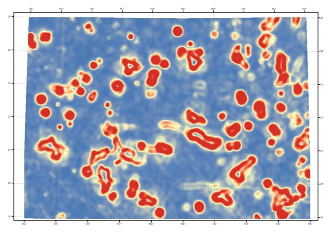
The first method consisted in the calculation of the gradients map the surface of the bottom of ocean, were allotted to the region of positive gradient, the exceeding 5 degrees.
The next steps were conducted:
1) Construction of the map of slope angles.
2) Averaging in the sliding window (12x12 km of cells) in order to remove the small forms of relief.
3) The contour lines of slope angles were built. Were selected contour lines - 5 degrees. (Angles of the slope of oceanic slope they do not exceed according to published data 5 degrees)
4) Was conducted the construction of ranges, in order to reveal the locked contour lines, (mountain - locked form of relief)
5) Were excluded the ranges, which fall inside other ranges, in order to remove from the examination of terrace, the flat apexes of guyots and other complications of relief. In this case for further analysis are marked the ranges, which have these internal complications of relief.
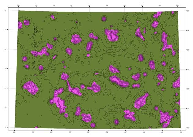
The second method consisted of the following:
1) The averaging of the initial map of depths with the very steep pitch (200 km) was conducted, in order to isolate background surface. This made it possible to reveal oceanic raising to contour them and to estimate their amplitude.
2) Seamountains were determined with the aid of the subtraction of the background of raising from the initial map of the bottom. In this case the positive and negative forms of relief with respect to the background were isolated.
3) Boundary was selected according to the method of natural boundaries (method of optimization on Dzhenku). This method groups close values and maximizes the differences between the classes. Boundaries are calculated from the formula of cluster analysis so that the intragroup dispersion would be less than between-group.
4) Generalization was conducted, small sections were removed.
The second method is simpler, and this method better reflects the form of seamountain, better are divided separate apexes in the chain of mountains, But in this case decreases the area of seamountain because with the averaging somewhat it is overstated background surface. But its basic advantage in the fact that it separates the positive and negative forms of relief in contrast to the gradient method. Also it is possible to separate terraces and flat apexes of guyots from the cavities. Terraces and apexes relate to the positive forms, and bends - to the negative. For the analysis are used different overlay operations GIS.
|
|
|
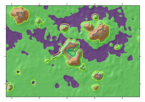
In the table are marked the ranges of the mountains, which have flat apexes (i.e. guyots). For solving the specific objectives should be combined these two methods. The second method is necessary for the exception of the negative forms of relief. But also for the isolation of the multi-connected ranges (volcanoes with the calderas and the annular structures, the atolls).
After the outlining of boarder and isolation of seamountains we have the possibility of the calculation of the individual characteristics of relief.
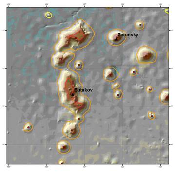
One of the primary tasks of analysis the estimation of the position of the center of mountain or volcanic crater. The centers of gravity of ranges were built for this. Further analysis of the obtained center with the form of the range of mountain makes it possible to isolate the chain of mountains (linear structures) with several apexes. And to separate them from the elongated raisings, whose origin is connected with the transform breakings. Also it is possible to isolate mountains, for which the center of gravity does not fall inside the range, for example for the same atolls or caldera structures.
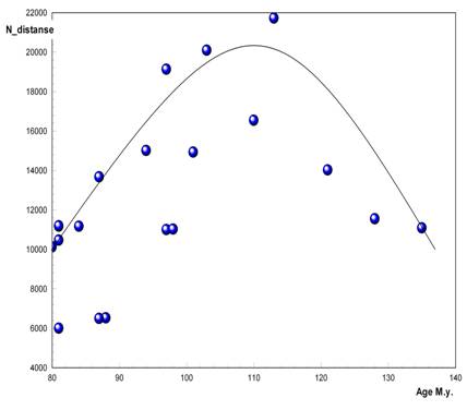
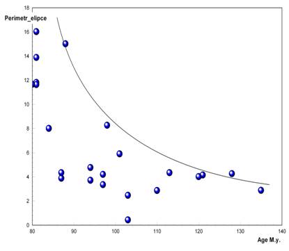
The degree of linearity reflects the conditions of tectonic stresses with the forming of volcanic cone. For the conditions of the center section of the oceanic raisings where predominate vertical tectonic motions the symmetry of underwater mountains high, for the limb zones and the ancient raisings of those subjected the field to the late tectonic breaking (for example for the plates near the island arcs) the degree of the stretchability of the chosen mountains is considerably above. For evaluating this parameter we found the smallest and greatest distance from the center of mountain to its outline. And their relation was calculated. In terms of the values the dependences on the age of their volcanism of that evaluated in the works were built calculated of the parameters for Magellan underwater mountains (Mitchell 2001, Рашидов et al 2003, Koppers et al 2003). For the majority of the parameters these dependences are distant from the linear (Fig.) which’s indicate the complex history of the forming of volcanic apparatus. With an increase in the age of underwater mountains the complexity of relief grows.
|
|
|
Reference.
1. Koppers A. P. , Staudigel H. , Pringle M. S. Wijbrans J. R. Short-lived and discontinuous intraplate volcanism in the South Pacific: Hot spots or extensional volcanis // Geochemistry Geophysics Geosystems. 2003. V. 4. № 10. P. 1-49.
2. Рашидов В.А. Магеллановы горы (Тихий океан): состояние геологической изученности // Вестник СВНЦ ДВО РАН. 2006. № 2. С. 13-20.
3. Мельников М.Е. Месторождения кобальтоносных марганцевых корок. Геленджик. ФГУГП ГНЦ. 2005г. 230 С.
4. General Bathymetric Chart of the Oceans (GEBCO)// http://www.gebco.net
5. Mitchell N.C. Transition from circular to stellate forms of submarine volcanoes. //Journal of Geophysical Research B: Solid Earth. 2001, 106 (B2), pp. 1987-2003.